Yankee Station Maps / Shell Back Certificate
Moderators: johnr, Marcella, Daveironbear, TheFith, Moderator
24 posts
• Page 1 of 2 • 1, 2
Yankee Station Maps / Shell Back Certificate
![]() by Mac » Tue Mar 24, 2009 8:47 pm
by Mac » Tue Mar 24, 2009 8:47 pm
I found a good one on USS Tucker DD 875 1965-1966 , it shows Yankee Station and surounding area very well . I don't know how to post it here though , if anyone can please do it. Or if you have other maps I'd like to see those too. There is also a " Shell Back " certificate shown there , and a card if anyones interested.
Mac
USS Hornet CVS 12 / VS-35 / AK3
1965-1967
Tonkin Gulf Yacht Club / VFW life member / BWNVVA member/ Not Pollywogg
USS Hornet CVS 12 / VS-35 / AK3
1965-1967
Tonkin Gulf Yacht Club / VFW life member / BWNVVA member/ Not Pollywogg
- Mac
- Posts: 395
- Joined: Mon Dec 01, 2008 11:32 pm
- Location: Kansas
Re: Yankee Station Maps / Shell Back Certificate
![]() by daklander » Tue Mar 24, 2009 9:04 pm
by daklander » Tue Mar 24, 2009 9:04 pm
Mac wrote:I found a good one on USS Tucker DD 875 1965-1966 , it shows Yankee Station and surounding area very well . I don't know how to post it here though , if anyone can please do it. Or if you have other maps I'd like to see those too. There is also a " Shell Back " certificate shown there , and a card if anyones interested.
What's the URL of the site?
There are pics and maps On the Blue Water Nave Web Site and I posted some great maps on one of the Blue Water Navy issues threads.
-

daklander - Posts: 752
- Joined: Tue Jan 06, 2009 3:06 pm
- Location: SoCal
Re: Yankee Station Maps / Shell Back Certificate
![]() by Mac » Tue Mar 24, 2009 9:28 pm
by Mac » Tue Mar 24, 2009 9:28 pm
It's Tucker DD 875 1965.pdf Adobe reader ,,, I'll look for better info. now.
Mac
USS Hornet CVS 12 / VS-35 / AK3
1965-1967
Tonkin Gulf Yacht Club / VFW life member / BWNVVA member/ Not Pollywogg
USS Hornet CVS 12 / VS-35 / AK3
1965-1967
Tonkin Gulf Yacht Club / VFW life member / BWNVVA member/ Not Pollywogg
- Mac
- Posts: 395
- Joined: Mon Dec 01, 2008 11:32 pm
- Location: Kansas
Re: Yankee Station Maps / Shell Back Certificate
![]() by Mac » Tue Mar 24, 2009 9:37 pm
by Mac » Tue Mar 24, 2009 9:37 pm
Here it is ,,, USS Henry W. Tucker DD 875 , its in 1965-1966 history of that ship. Does this work ? Let me know. And I've looked at the maps here , these are different than what I've seen.
Mac
USS Hornet CVS 12 / VS-35 / AK3
1965-1967
Tonkin Gulf Yacht Club / VFW life member / BWNVVA member/ Not Pollywogg
USS Hornet CVS 12 / VS-35 / AK3
1965-1967
Tonkin Gulf Yacht Club / VFW life member / BWNVVA member/ Not Pollywogg
- Mac
- Posts: 395
- Joined: Mon Dec 01, 2008 11:32 pm
- Location: Kansas
Re: Yankee Station Maps / Shell Back Certificate
![]() by Mac » Tue Mar 24, 2009 9:58 pm
by Mac » Tue Mar 24, 2009 9:58 pm
Heres another way there, hwtucker2000.com/TheTucker_ourship_History.htm, then down page to History 1965-1969 ,,,,,,,,,,  Sorry I'm not better at this.
Mac
USS Hornet CVS 12 / VS-35 / AK3
1965-1967
Tonkin Gulf Yacht Club / VFW life member / BWNVVA member/ Not Pollywogg
USS Hornet CVS 12 / VS-35 / AK3
1965-1967
Tonkin Gulf Yacht Club / VFW life member / BWNVVA member/ Not Pollywogg
- Mac
- Posts: 395
- Joined: Mon Dec 01, 2008 11:32 pm
- Location: Kansas
Re: Yankee Station Maps / Shell Back Certificate
![]() by Mac » Tue Mar 24, 2009 10:16 pm
by Mac » Tue Mar 24, 2009 10:16 pm
Another interesting map there is in -section 4-15- it shows a path of a " Super Typhoon Path in August 1964 " Section 4- 15" ,,, wonder if that might have moxed up the water in the Gulf of Tonkin any ? And Thailand too for that matter.
Mac
USS Hornet CVS 12 / VS-35 / AK3
1965-1967
Tonkin Gulf Yacht Club / VFW life member / BWNVVA member/ Not Pollywogg
USS Hornet CVS 12 / VS-35 / AK3
1965-1967
Tonkin Gulf Yacht Club / VFW life member / BWNVVA member/ Not Pollywogg
- Mac
- Posts: 395
- Joined: Mon Dec 01, 2008 11:32 pm
- Location: Kansas
Re: Yankee Station Maps / Shell Back Certificate
![]() by Latergator » Tue Mar 24, 2009 10:22 pm
by Latergator » Tue Mar 24, 2009 10:22 pm
Mac wrote:Here it is ,,, USS Henry W. Tucker DD 875 , its in 1965-1966 history of that ship. Does this work ? Let me know. And I've looked at the maps here , these are different than what I've seen.
MAC, I got a clear copy of that map by opening the PDF file with Photoshop CS3, (yes you can open a PDF in Photoshop! If it has more than one page, it will let you select the page). I then turned the PDF page into a JPG file and then did a crop to show only the map.
Now here is the kicker, the photo has to be on a website as a JPG to begin with. When you use the "Img" above to add a picture, it looks for a web location to copy from. Send me your email address and I will send the picture of the map to you. I cannot sned it through this board because it must be a website to do that!
But the next best thing might be this:
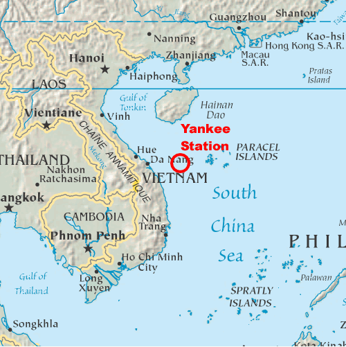 Which is from Wikipedia "Yankee Station" You just click on the image and select "copy image address and place it between the markers you get when you select "Img" from the top of the posting area.
Wally
Latergator
USS Canberra CAG2
Member, Fleet Reserve Association
Member, Blue Water Navy Vietnam Veterans' Association
Naval Association of Australia, Victoria
No one left behind
BWNVVA Library: http://www.bluewaternavy.org/
Latergator
USS Canberra CAG2
Member, Fleet Reserve Association
Member, Blue Water Navy Vietnam Veterans' Association
Naval Association of Australia, Victoria
No one left behind
BWNVVA Library: http://www.bluewaternavy.org/
-

Latergator - Site Admin
- Posts: 1147
- Joined: Fri Sep 21, 2007 7:19 am
- Location: Manassas, VA
Re: Yankee Station Maps / Shell Back Certificate
![]() by Mac » Tue Mar 24, 2009 10:27 pm
by Mac » Tue Mar 24, 2009 10:27 pm
Thanks Wally, I wanted to post that stuff on here the map and the typhoon path may be helpful to our cause. I saved it all on my computer.
Mac
USS Hornet CVS 12 / VS-35 / AK3
1965-1967
Tonkin Gulf Yacht Club / VFW life member / BWNVVA member/ Not Pollywogg
USS Hornet CVS 12 / VS-35 / AK3
1965-1967
Tonkin Gulf Yacht Club / VFW life member / BWNVVA member/ Not Pollywogg
- Mac
- Posts: 395
- Joined: Mon Dec 01, 2008 11:32 pm
- Location: Kansas
Re: Yankee Station Maps / Shell Back Certificate
![]() by Mac » Tue Mar 24, 2009 10:48 pm
by Mac » Tue Mar 24, 2009 10:48 pm
Wally ,The two maps show Yankee Station in different places ,,,, I wonder why ?
Mac
USS Hornet CVS 12 / VS-35 / AK3
1965-1967
Tonkin Gulf Yacht Club / VFW life member / BWNVVA member/ Not Pollywogg
USS Hornet CVS 12 / VS-35 / AK3
1965-1967
Tonkin Gulf Yacht Club / VFW life member / BWNVVA member/ Not Pollywogg
- Mac
- Posts: 395
- Joined: Mon Dec 01, 2008 11:32 pm
- Location: Kansas
Re: Yankee Station Maps / Shell Back Certificate
![]() by daklander » Wed Mar 25, 2009 10:30 am
by daklander » Wed Mar 25, 2009 10:30 am
There's a fine, free, place on the web that's easy to use for posting photos if you don't have a website. It is TinyPic. Easy to sign up and no spam that I've noticed. You can also post pictures without signing up but than cannot get back to them. Tiny Pic seems to be easier to use than Photo Bucket and other photo posting sites I've tried and it's been much faster with fewer downtime issues. At least it's been available every time I've tried to use it, unlike some of the others that were down and unavailable.
Also, most pdf readers have a tool that you can use to select particular type to input into a document and edit it and to select photos in the pdf as well. I don't normally use Windows but I remember Adobe Reader having that capability and I think Fox Reader does as well.
Also, most pdf readers have a tool that you can use to select particular type to input into a document and edit it and to select photos in the pdf as well. I don't normally use Windows but I remember Adobe Reader having that capability and I think Fox Reader does as well.
-
daklander - Posts: 752
- Joined: Tue Jan 06, 2009 3:06 pm
- Location: SoCal
Re: Yankee Station Maps / Shell Back Certificate
![]() by Mac » Wed Mar 25, 2009 10:48 am
by Mac » Wed Mar 25, 2009 10:48 am
Hey Thanks daklander ,
Those are the ones I meant. Notice yankee station is different on those two maps ? On this map it says it's 120 miles from east to west Hainan to Vietnam , and Carriers were in the middle , 60 miles each way roughly , and steaming into the wind usually to launch and recover planes ( we could see land , had to hold course till planes got recovered) ) so how close were our escorts ?
When I origionally went to VA the VSO was telling me that A/C Carriers were hundereds of miles off coast , so we ( BWN ) had a tough time winning a claim for that reason , typical Army dude response. Thats why map is of interest in my opinion. Thank you and I'll check your website.
Mac
USS Hornet CVS 12 / VS-35 / AK3
1965-1967
Tonkin Gulf Yacht Club / VFW life member / BWNVVA member/ Not Pollywogg
USS Hornet CVS 12 / VS-35 / AK3
1965-1967
Tonkin Gulf Yacht Club / VFW life member / BWNVVA member/ Not Pollywogg
- Mac
- Posts: 395
- Joined: Mon Dec 01, 2008 11:32 pm
- Location: Kansas
Re: Yankee Station Maps / Shell Back Certificate
![]() by daklander » Wed Mar 25, 2009 10:58 am
by daklander » Wed Mar 25, 2009 10:58 am
Yankee Station was located about 190 km due east of Dong Hoi, at 17° 30' N and 108° 30' E, about 120 miles....
Or, it was located 160 km from the coast, at 16° N latitude and 110° E longitude, about 100 miles. Which is really correct?
The map Latergator posted is probably more concise in location whereas the one from the Tucker is a general area.
Or, it was located 160 km from the coast, at 16° N latitude and 110° E longitude, about 100 miles. Which is really correct?
The map Latergator posted is probably more concise in location whereas the one from the Tucker is a general area.
Last edited by daklander on Wed Mar 25, 2009 11:07 am , edited 1 time in total.
-
daklander - Posts: 752
- Joined: Tue Jan 06, 2009 3:06 pm
- Location: SoCal
Re: Yankee Station Maps / Shell Back Certificate
![]() by Mac » Wed Mar 25, 2009 11:02 am
by Mac » Wed Mar 25, 2009 11:02 am
Wonder if Tucker is showing the PIRAZ zone ? It was established in around 1965 , as I recall.
Mac
USS Hornet CVS 12 / VS-35 / AK3
1965-1967
Tonkin Gulf Yacht Club / VFW life member / BWNVVA member/ Not Pollywogg
USS Hornet CVS 12 / VS-35 / AK3
1965-1967
Tonkin Gulf Yacht Club / VFW life member / BWNVVA member/ Not Pollywogg
- Mac
- Posts: 395
- Joined: Mon Dec 01, 2008 11:32 pm
- Location: Kansas
Re: Yankee Station Maps / Shell Back Certificate
![]() by Mac » Wed Mar 25, 2009 7:29 pm
by Mac » Wed Mar 25, 2009 7:29 pm
I also know I was in the Gulf of Tonkin several times , always wondered about all that. I guess south of Hainan must still be the Gulf ?
Mac
USS Hornet CVS 12 / VS-35 / AK3
1965-1967
Tonkin Gulf Yacht Club / VFW life member / BWNVVA member/ Not Pollywogg
USS Hornet CVS 12 / VS-35 / AK3
1965-1967
Tonkin Gulf Yacht Club / VFW life member / BWNVVA member/ Not Pollywogg
- Mac
- Posts: 395
- Joined: Mon Dec 01, 2008 11:32 pm
- Location: Kansas
Re: Yankee Station Maps / Shell Back Certificate
![]() by Latergator » Thu Mar 26, 2009 1:15 am
by Latergator » Thu Mar 26, 2009 1:15 am
While we are talking about maps, I had the funniest thing happen to me while checking my deck logs. The first time I was in the bay of DaNang and its harbor, the deck log contains an error! It missed the latitude by a whole degree! We were crusing all over the harbor in the deep water areas, but the deck log shows clearly we were on land!
I wonder what the DVA would say about a heavy cruiser being in country?
I wonder what the DVA would say about a heavy cruiser being in country?
Wally
Latergator
USS Canberra CAG2
Member, Fleet Reserve Association
Member, Blue Water Navy Vietnam Veterans' Association
Naval Association of Australia, Victoria
No one left behind
BWNVVA Library: http://www.bluewaternavy.org/
Latergator
USS Canberra CAG2
Member, Fleet Reserve Association
Member, Blue Water Navy Vietnam Veterans' Association
Naval Association of Australia, Victoria
No one left behind
BWNVVA Library: http://www.bluewaternavy.org/
-
Latergator - Site Admin
- Posts: 1147
- Joined: Fri Sep 21, 2007 7:19 am
- Location: Manassas, VA
24 posts
• Page 1 of 2 • 1, 2
Who is online
Users browsing this forum: Yahoo [Bot] and 1 guest