Blue Water Navy Association's description of the project and directions for assisting with project.
Definition and Description of BASELINE
It is Blue Water Navy Association's intention that the Territorial Seas be measured as 12-miles from Baseline. This Map shows the Baseline as red and the limits of the Territorial Sea as a dashed line. Note where it stand out from the shoreline.
Click here for an official site of the State Department defining Vietnam's Baseline with an additional map
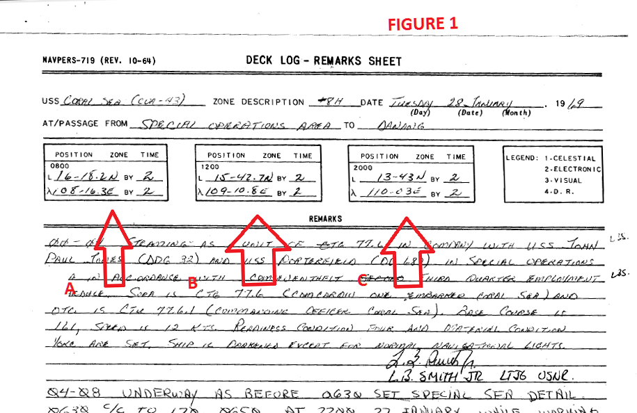
For verification, here are the entries from the SecNav1650 for the dates that each ship was in the Theater of Combat. This was tracked because they were awarded a medal and ribbon each time they are within the Theater of Combat, which is the identical area designated as where any ship and her crew receive the Vietnam Service Ribbon (VS). The Armed Forces Expeditionary Medal (AE) was awarded when a ship was in the combat zone prior to the creation of the Vietnam Service Medal (1962 through July 3, 1965). That specific instance of the AE medal (noted as AE-I) can be switched for the Vietnam Service Medal by contacting the Review Board that will then issue a DD-215 showing this correction/change to the DD-214. This cannot be done with any other AE award.
There were two more instances when the Armed Forces Expeditionary Medal was awarded during the 9 Jan 62 and 7 May 75 window when presumptive exposure to Agent Orange is recognized for those with boots-on-ground.
This program requires Google Earth be loaded on your machine.
What we are providing here is a program that opens Google Earth, so you need to have downloaded the free Google Earth program and installed it on your computer on your own hard drive.
According to current proposed legislation, it *MAY* be necessary to prove your ship was inside the area between this line and the shore line. This line represents the 12-miles from Baseline that we intend the legislation to refer to if that language stays as is.
When you open the Google Earth program, go to the TOOLS on the Google Earth Menu Bar at the top, choose OPTIONS, and than choose the tab 3-D VIEW. Go to the box marked SHOW LAT/LONG and choose DEGREES, DECIMAL MINUTES. This is because most notations of Latitude and Longitude found in Ship Deck Logs generally used the Degree, Decimal Minute format.
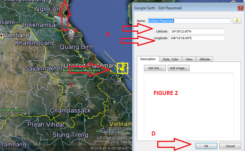
Note that at the bottom of the Google Earth window, there is a display of the latitude and longitude that changes as your cursor controlled by the mouse is moved. Wherever that cursor stops shows an exact latitude and longitude to match-up with a reading from the Deck Log.
Directions on checking a ship's location using Google Earth
To double check that the co-ordinates were properly keyed in: right click on the pin you placed, and then click PROPERTIES. This will open that dialogue box and show the co-ordinates it defines. Note that these co-ordinates took the decimal minutes and converted them to minutes and seconds. To convert decimal minutes to minutes and seconds, multiply the decimal number by 60. Example: 28.2 minutes is 28+(.2*60)= 28 min 12 seconds.
Some basics for using Google:
You can click on the SHIPLOCATION.kmz file to open Google Earth. Or, when Google Earth is already open, clicking on the .kmz file should move your view to the coast of Vietnam.
When you first open Google Earth you may see a tip window. Close that by clicking on CLOSE.
Use the Navigation Controls that appear in the upper right corner of the Google Earth Window when you move your cursor there. You can then use the ZOOM IN [+] or ZOOM OUT [-].
When your cursor is in the shape of a hand, you can hold down the left mouse button to move the map around.
If you go to the top menu, under VIEW, and click on the GRID selection, the Latitude and Longitude lines for the entire globe will be available, and will scale to your location as you zoom in and zoom out.
If you need assistance using Google Earth please contact [email protected] via e-mail.
Ray Melninkaitis has created an instructional video about placing pins on Google Earth with the Vietnam Territorial Seas subroutine active. This will help anyone wishing to see exactly where any set of Latitude and Longitude lines cross on the map. Ray will be taking the lat/long numbers from a typical Deck Log. Anyone wanting to find the location of their ship at a particular Deck Log entry for the Latitude and Longitude should find this helpful.
Ray will be keeping track of which carriers can be shown by Deck Log to have been in the Territorial Seas of Vietnam. Figure 3 (May 30, 2015 Update) is a spreadsheet he will use to record those ships. Please coordinate through Ray before undertaking any extensive research regarding your ship's location so we don't have a duplication of effort going on. We would like a volunteer from each carrier to take on the job of completing the research. Anyone willing to look at additional ship Deck Logs is certainly invited to let us know that also. Following the carriers, we will be getting digitized Deck Logs of ammumition ships, and oilers. We will do the same thing for each Hull Type.Digitizing the Deck Logs is a MONUMENTAL project. Those who want Deck Logs of ships not currently on the scan schedule can still get them from NARA as hard copies.
More information on this aspect of the project will be forthcoming as we move forward with identifying which ships qualify under the current direction of this Legislation.
Here is a pdf of the Summary Page of the carriers that have been located so far. REMEMBER, we have not yet looked at all carrier Deck Logs for the entire War period yet. The details are in the spreadsheet above.
TRACKING THE AMMO SHIPS (AE)
This Calendar Graphic shows when an ammunition ship was within the Theater of Combat between 1962 and 1975. When those Deck Logs are reviewed (Hopefully this will happen by mid-2016), dates when the AE was within Territorial Seas will be marked.
TRACKING THE OILERS (AO)
This Calendar Graphic shows when a Fleet Oiler (Hull Type AO) was within the Theater of Combat between 1962 and 1975. When those Deck Logs are reviewed (Hopefully this will happen by mid-2016), dates when the AE was within Territorial Seas will be marked.
When that Hull Type as been completed, we will move on to other type ships. We are starting with thips that are LEAST LIKELY to have been in the Territorial Seas on every WESTPAC Deployment.
At this time, the best way to access the NARA site for viewing of Deck Logs is to use the Spreadsheet of the "ALL SHIP TYPES ..." link given below. Find the ship and corresponding Deck Log Month and click that link. If your ship or the specific month is not listed, it is not yet available for Public Access viewing. But this scanning project is currently underway and updated here monthly.
The easy way to a deck logs is via the NARA spreadsheet, Of course, this requires that the user have Excel (or some app that can open Excel files).
Using this approach:
This approach is used for logs that NARA believes are available per their spreadsheet.
Second approach:
For the search term, examples such as these have worked:
Sometimes not all available logs were not found using this approach. The jury is still out. It will require more experimentation and perhaps help from NARA.
Here is an updated Spreadsheet of ALL SHIPS TYPES of the Vietnam War Era showing Deck Logs for that ship's activities for a specific month and year of that ship while in the Theater of Combat. These have been scanned and posted for no-cost public access on the National Archive's OPA - Open Public Access records. Note the bottom of the Excel spreadsheet has TWO TABS: a tab for the completed list of scans, and a tab for additions to the list since last update. NOTE: You can toggle between the entire list and the list of the new Deck Logs added since the last update using the TABS at the bottom.
This Spreadsheet is valid as of December 18, 2015
There are now 225 ships and 9,614 Monthly Deck Logs for all Naval Ships. These Deck Logs as of December 18, 2015 are scanned and available for viewing and downloading. This Spreadsheed contains some ships not in the 1961 to 1975 time window, but our emphasis is on the ships of that Vietnam Era.
This month 451 logs from 31 ships (including submarines) were added.
Here is an Excel FINDING AID developed by "Skip" Sander of The USS Rankin Association. This is based on the Oct. 22 spreadsheet of all available ship decklogs in the NARA Public Access Site as of that date.
RETURN TO The Newspage